ArcGIS Military Analyst 10.1

Free ArcGIS extension with geospatial analysis capabilities for mlitary applications
3.6 
Rating
Your vote:
Latest version:
10.1.3035 See all
Screenshots
1 / 2
Awards (1)
Show all awards
Software Informer Virus Free award
Download
Free   29.8 MB

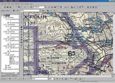
ArcGIS Military Analyst is an ArcGIS extension consisting of a suite of utilities and API designed to enhance the geospatial analysis capabilities of the defense/intelligence user community, specifically those who want to manage and exploit National Geospatial‑Intelligence Agency (NGA) Raster Product Format (RPF) data, Vector Product Format (VPF) data, and Digital Terrain Elevation Data (DTED).

Comments

3.6
Rating
7 votes
5 stars
3
4 stars
1
3 stars
1
2 stars
1
1 stars
1
User

Your vote:

Related software

ArcGIS Engine Runtime
rating

ArcGIS Engine is a complete library of embeddable GIS components for developers.

ET Surface for ArcGIS
rating

It is a set of tools for ArcGIS that enable the users to create surfaces.

ArcGIS Military Overlay Editor
Free
rating

Military Overlay Editor (MOLE) is a set of COM components for developers

ArcGIS Image Server AutoCad Client
ArcGIS Image Server AutoCad
Free
rating

You can view an image service using various client applications.

Canvas X 2017 GIS
Canvas X 2017 GIS
rating

Geospatial mapping and analysis tool with ESRI file support.

Related suggestions